It’s been over a year since I’ve posted in this blog, here is a brief update on my current project.
Roaming the Proterozoic:
I have been to three sites thus far in my Roaming the Proterozoic series, looking for the stories in the Precambrian rocks of the Avalon Peninsula. I visited Murray’s Peak in Seal Cove; Finn Hill and Burke’s Cove in Colliers; and Double Road Point in St. Mary’s.
Roaming the Proterozoic:
I have been to three sites thus far in my Roaming the Proterozoic series, looking for the stories in the Precambrian rocks of the Avalon Peninsula. I visited Murray’s Peak in Seal Cove; Finn Hill and Burke’s Cove in Colliers; and Double Road Point in St. Mary’s.
On Murray’s Peak I was looking for intimately intruded
granite and trap rock as reported by A.F. Buddington in 1914 during field work in Newfoundland from Princeton University. Here's an image of his notes, the 2nd last line in the first paragraph inspired me to look for love among the rocks!
Accession 18-040, Archives and Special Collections
I didn’t clearly see the intimately penetrating intrusions
but I did find plenty of granite and trap fragments sitting together on the
outcrop, overlooking Conception Bay…
I also got to the top of Finn Hill in Colliers seeking the ignimbrite
sequence described in V.J. Papezick's paper Late Precambrian Ignimbrites on the Avalon Peninsula in 1969. 50 years of vegetation growth prevented me from
seeing it clearly as outlined in his paper but I did find an example of
pyroclastic rock resting peacefully in Burke’s Cove as noted in Graham Nixon’s
thesis from 1974, Late Precambrian (Hadrynian) ash-flow tuffs and associated rocks of the Harbour Main Group near Colliers, Avalon Peninsula, S.E. Newfoundland
Nixon, 1974
The colours and textures of these volcanic rocks are stunning. These rocks were once gas, dust and debris; part of a violent explosion from a volcanic eruption, known as a pyroclastic flow moving rapidly down hill and destroying everything in its path. They now sit peacefully on the shores of Colliers Bay.
I left the Harbour Main Group of rocks and moved up to the
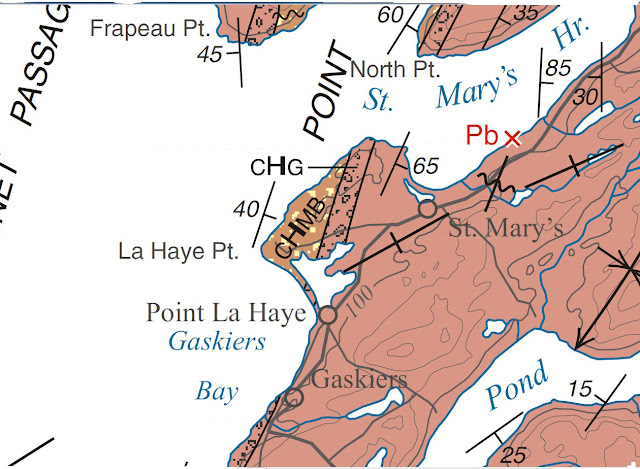
Conception Group in a GSC report by Hank Williams and Arthur King, Memoir 389, Trepassey Map Area, Newfoundland. I was interested in the mixtites and rhythmites shown in the Gaskiers Formation at Double Road Point, St. Mary's. It is the area marked CHG in the center of the map image below. Some fabulous rocks here along the shoreline
and a place to revisit in the Spring.
This Spring/Summer/Fall I intend to spend more time roaming, climbing up the geological time scale from Trinny Cove to Bristy Cove and Lower Island Cove to Lears Cove and points in between. Should be fun!

A portion of Geological Map of the Avalon Peninsula, A.F. King, 1990
This Spring/Summer/Fall I intend to spend more time roaming, climbing up the geological time scale from Trinny Cove to Bristy Cove and Lower Island Cove to Lears Cove and points in between. Should be fun!


