Sunday, 15 November 2015

Howley and the Beothuk and Tickle Cove Broad, The Process

Archaeology

On November 5th I attended a symposium by the Newfoundland and Labrador Archaeology Society in commemoration of the 100th anniversary of James P. Howley's book "The Beothuk or Red Indians".  Below is a link to the keynote address by Gerry Penney from the Archaeology Society's webpage.  Thank you Gerry for sharing!

James P. Howley, “the birth of Newfoundland archaeology, and the end of history” (PDF).

Howley extensively researched the Beothuk and mentions them often in his Reminiscences, His book recounts the history of the Beothuk encounters with the European explorers and settlers and their eventual extinction.  It is the first comprehensive book about the Beothuk and has been for many decades.  The book is also available on-line from the Queen Elizabeth II Library's Digital Archive Initiative website:

http://collections.mun.ca/cdm/compoundobject/collection/cns/id/26831/rec/577

Art

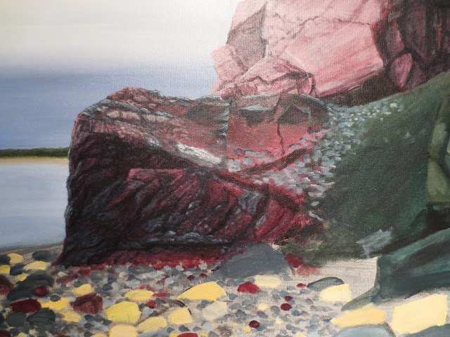
I thought I would show the painting process of Tickle Cove Broad.  I started work on it October 22nd. I usually sketch out the image on large paper in reverse then transfer it onto the canvas with tracing paper but I didn't follow that procedure with this one.  The basic outline is less complicated I think than the previous I've worked on...or maybe I just got lazy!

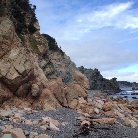
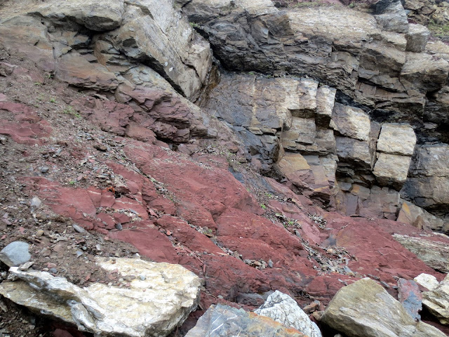
So, I started outlining the shapes, then filled them in with the basic colour, did background and sky, I usually get that out of the way first so I can concentrate on the geology.  As I'm blocking in the colour my eye keeps scanning the photos for the detail.  On first glance the cliffs look like they are three different colours but as I get closer and closer I see the variations in each rock type.


In his field book Howley stated that on the west side of Tickle Cove Broad there were cliffs of red, yellow and green rock all jumbled together.  The more I progress, the more I see bits of green mixed in amongst the red, and yellow into the green.  


I sometimes forget the detail that goes into the pieces and figure I can whip up one section with a few brush strokes...but the rock drags me in and I start working with my tiniest detail brush, layer after layer in small areas.  It's like geological time, structures are formed and built up and taken away over millions of years.  I feel I am building and building colour and texture slowly, like geological time and even though this step is the most onerous, it is the one I like best.  There's an intimacy about it, I feel very connected to the structure as I unravel its mysteries.


Friday, 9 October 2015

Three Rock Cove, Tickle Harbour Broad and some important dates.

I have finally completed the Three Rock Cove painting, here are a couple of images, half-done and finished:


This one was more challenging than the Brigus cross-section, so much texture in the rock here.  The next painting coming down the pipe is the red, yellow and green rocks all jumbled together at Tickle Harbour Broad, a.k.a. Bellevue Beach.  


I don’t understand why the name was changed, Tickle Harbour Broad seems like a true Newfoundland name, though these days it would probably be called THB!  I have been to this beach many times before I found reference to it in Howley’s 1869 field book so I was very familiar with the geology there.  I had done a painting of some of the yellow sandstone while in art school back in the late 80’s and always felt it was a special place.


The rocks here are so interesting and it is an easy place to spend a day wandering and sketching.  


Here is an excerpt from the field book:

August 24, 1869

Altogether the cliffs are very peculiar composed of red, yellow and green rock all jumbled together and having a smooth slippery appearance.  There are some small quartz veins cutting through here and there, some of which are …on both sides by a curious green fibrous mineral in some places nearly two inches thick.  

Some important dates:

I have changed the date of the exhibition to September 2017.  I have four more pieces to complete and at the rate I’m going the timing would be perfect.

Also, below is a link to information about a symposium by the NL Archaeological Society in honour of the 100th anniversary of James P. Howley’s book “The Beothuk or Red Indians”.  In researching his field books I found he often mentions the Beothuk and looked for traces of them while surveying in the interior.  The symposium will be held in the Landing at the University Center, November 5, 7:00 – 8:30.  It should be an interesting event!

http://nlarchsociety.ca/2015/09/30/symposium-in-honour-of-the-100th-anniversary-of-james-p-howleys-book-the-beothucks-or-red-indians/

Saturday, 8 August 2015

It's all about the rocks

Last year on my trip to Dantzic Cove I felt I hadn't really spent enough time at the site and went away too soon, not investigating properly what Howley described as a "great deal of disturbance".  This summer I planned a family vacation to the Burin Peninsula in order to get back there.  My husband, son, his friend and I spent four days in Garnish which included kayaking, golfing, swimming and a hike back to Dantzic Cove.


This time I got up close and personal with the rocks.  It's so much better to be able to touch and observe the rocks then look at them from a camera lens, because of an impending thunderstorm that's all I did when I first visited there in 2014.  This time I walked all over them, all the way out to the end as far as I could safely go.  In Howley's field book of 1870 he states "here all was confusion" and I certainly saw that. There was no clear pattern in the structure, nothing but a jumble of  textures, shapes and colours in this little gulch.


As an "arm chair" geologist I don't know how to describe what kind of energy was required to create such a convoluted structure.  I recognize folding and a geological map of the area shows that a fault runs through here.  But despite all that cataclysmic action in the past, I got a peaceful, quiet feeling from the place, as if the earth's processes had finished all it had to do here and left the rocks in a tight squeeze with each other..like a geological group hug!


Saturday, 6 June 2015

Catching Up - Accolades for James P. Howley

I haven't posted anything in a while, it has been a long Spring and I've had two bad colds and a stomach bug, but I'm back on my feet again and still working on the Three Rock Cove piece.  I am very pleased with how it is coming about.  I love fleshing out the shapes and textures I find in these structures.  Things I didn't even notice until I have brush in hand, standing in front of the canvas and intensely studying the photographs from the site; curved lines, jagged lines, broken lines, smooth here, rough there, split apart, caved in...what stories these rocks tell!


In an earlier post (October 2013) I mentioned that James P. Howley's name was put forward to the Historic Sites and Monuments Board of Canada to be considered as a person of historical significance.  I found out recently that the Board had accepted the nomination and Howley is now a person of historical significance in Canada!  This means he will be marked by a plaque at The Rooms.

Here's an excerpt from the Minutes of July 2012 Board meeting:

Four significant points for which he was recommended for designation:

1. His study of the Beothuk Indians published in 1915 remains the cornerstone of all subsequent research on the subject;
2. He is regarded as the creator of the institution that became the provincial museum in Newfoundland and Labrador and served as its first curator, overseeing the consolidation and expansion of core collections;
3. He trained under Alexander Murray, his work as an assistant and then as Director of the Geological and Topographical Survey of Newfoundland between 1868 and 1909 produced much of the scientific basis for understanding the geography of the interior Newfoundland, its geology and mineral deposits;
4. His memoirs are a valuable record of Newfoundland's earliest scientific explorations from a personal perspective and constitute a unique historical record of late 19th and early 20th century Newfoundland life beyond St. John's.

In my early days of research I was fascinated with the writings from his field books.  The geology was interesting in itself for me but his tales of travelling around the province on foot and visiting the outports were truly a glimpse of Newfoundland at that time.  I enjoyed seeing the landscape through his eyes, the grand vista of the Humber Valley from Mount Seemore and the pleasures of canoeing a "verdant" tree-lined steady.  From sleeping in "comfortable quarters" to shivering in a "miserable tilt", his enthusiasm for fieldwork was infectious and I found myself wondering why he wasn't really well known to the general public.

Many thanks to Gerald Penney and Derek Wilton for submitting this nomination.


Thursday, 9 April 2015

All roads lead to here

I have secured a space for the exhibition of the art work for the Howley project!  The First Space Gallery at the Queen Elizabeth II Library will host the exhibit during the Winter semester of 2017.


The library is a perfect fit for the exhibition, it is also my work place and my job in the Map Room led me to research Howley.  I have easy access to his maps and his personal papers and field books are just one floor away in the Archives and Special Collections Division.  Would I have done this body of work had I not worked in the Library... maybe not, thus the title of the series "All Roads Lead to Here".


I am glad to have a deadline at last!


Wednesday, 11 February 2015

Three Rock Cove, Port au Port Peninsula


Finished the Brigus cross-section and now doing some preliminary work on the next one: Three Rock Cove, on the Port au Port peninsula. Three Rock Cove was one of the early entries in my Howley research journal, I had read the official survey report for 1874 and for some reason the place stuck in my head.  


Here’s a quote from the report:  "At a place called Shoal Cove, about 8 miles from the extreme end of Long Point from the Gulf side, rocks of the lower carboniferous horizon form a narrow strip along the shore south westwards to a place called Three Rock Point where they run out into the sea.  These strata consist of red miceaceous sandstones and conglomerates with a few thin beds of limestone which contain carboniferous fossils.”

There was something in the “red miceacous sandstone” that Howley described that made me want to have a look at this place, perhaps it was the word “miceacous”, it has a textural ring to it. I could just picture these bands of rock dipping down to disappear underneath the waves, I really felt there was something there.

I did this journey as part of the NLAC project grant which also included an investigation of Long Point, (the tale told in an earlier post) and once again I was not disappointed in the structures found here.  Three Rock Cove is an easy area to access, a nice beach flanked the red striped cliffs.

 There was a lot of red sandstone and the unmistakable limestone but I was unsure of the conglomerate.  Even though my viewpoint was from the beach and not the water the formation did clearly end at Three Rock Point where the cliffs level out to the shore.  The red sandstone layer gets smaller and limestone dominates the cliffs until it runs out at the three rocks, thus named Three Rock Cove.


All along this shore there were huge slabs of limestone that I would have loved to bring home to make a patio in my backyard.  There were interesting rocks on the beach as well, some were polka dotted with limestone and reminded me of Pop art.  The cliff faces were the most interesting however, full of textures and patterns.


The painting I will be doing is from the image below, not exactly at Three Rock Point but a little further north along the shore where I felt the composition was more interesting. The layers seem to disappear underneath the beach.