Tuesday, 17 March 2020

A Year Later


It’s been over a year since I’ve posted in this blog, here is a brief update on my current project.

Roaming the Proterozoic: 

I have been to three sites thus far in my Roaming the Proterozoic series, looking for the stories in the Precambrian rocks of the Avalon Peninsula. I visited Murray’s Peak in Seal Cove; Finn Hill and Burke’s Cove in Colliers; and Double Road Point in St. Mary’s.

On Murray’s Peak I was looking for intimately intruded granite and trap rock as reported by A.F. Buddington in 1914 during field work in Newfoundland from Princeton University.  Here's an image of his notes, the 2nd last line in the first paragraph  inspired me to look for love among the rocks!


Accession 18-040, Archives and Special Collections

I didn’t clearly see the intimately penetrating intrusions but I did find plenty of granite and trap fragments sitting together on the outcrop, overlooking Conception Bay…


I also got to the top of Finn Hill in Colliers seeking the ignimbrite sequence described in V.J. Papezick's paper Late Precambrian Ignimbrites on the Avalon Peninsula in 1969.  50 years of vegetation growth  prevented me from seeing it clearly as outlined in his paper but I did find an example of pyroclastic rock resting peacefully in Burke’s Cove as noted in Graham Nixon’s thesis from 1974, Late Precambrian (Hadrynian) ash-flow tuffs and associated rocks of the Harbour Main Group near Colliers, Avalon Peninsula, S.E. Newfoundland
Nixon, 1974


The colours and textures of these volcanic rocks are stunning.  These rocks were once gas, dust and debris;  part of a violent explosion from a volcanic eruption, known as a pyroclastic flow moving rapidly down hill and destroying everything in its path. They now sit peacefully on the shores of Colliers Bay.


I left the Harbour Main Group of rocks and moved up to the 
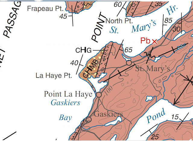
Conception Group in a GSC report by Hank Williams and Arthur King, Memoir 389, Trepassey Map Area, Newfoundland.  I was interested in the mixtites and rhythmites shown in the Gaskiers Formation at Double Road Point, St. Mary's.  It is the area marked CHG in the center of the map image below.  Some fabulous rocks here along the shoreline and a place to revisit in the Spring.


 A portion of Geological Map of the Avalon Peninsula, A.F. King, 1990


This Spring/Summer/Fall I intend to spend more time roaming, climbing up the geological time scale from Trinny Cove to Bristy Cove and Lower Island Cove to Lears Cove and points in between.  Should be fun!


Wednesday, 27 February 2019

Winter Pursuits - planning for Spring, Summer and Fall


I’m passing the winter in my studio getting ready for another solo exhibition at a little cafĂ© in Port Rexton, the Two Whales.  The opening is on September 1st and the work can be seen until the 30th.  In 2018 I visited several beaches on the Bonavista Peninsula and found a lot of subject matter for a dozen or so paintings for the exhibition.


From reading the Geological Association of Canada Field Trip Guide, September 29 - Oct 1, 2017, titled: Depositional settings and tectonic evolution of rocks of the Bonavista Peninsula: new constraints and queries for Avalonia I found a few places with interesting rocks to paint.

From that report I discovered the beautiful and secluded Spaniard’s Cove on the road to Old Bonaventure and spent a quiet morning sketching in the sun.


I also went to Brook Point Cove and spent a few hours there sketching out that vibrant formation.  I may paint a part of it.  It’s a nice spot to sit and listen to the ocean … and the rocks.


The southwest end of Keels was equally nice. I was told it is known as the Turkish shore. On a quiet little beach I found some interesting formations  caused by water erosion. 


So...continuing with my current research...

For this new series of geologic paintings, Roaming the Proterozoic,  I am following the geological time scale from oldest to youngest Precambrian rocks on the Avalon Peninsula.  I have relied heavily on the map “Geology of the Avalon Peninsula” by Dr. Arthur King, produced in 1988.  It graces the walls of my studio and is an excellent reference source.


I’ve sketched out a sequence for myself and am filling in sites to visit in each section from information gleaned from geology reports and the Avalon Peninsula geology map.


I will be filling in the details of each location as I visit there.  This piece of gloss paper is 5 inches x 48 inches.  I anticipate several incarnations of this as I work through the formations.  

The oldest rocks on the Avalon are found in what's known in geological circles as the Harbour Main Group.  I have been researching good places to see them, off the beaten track preferably.  I have decided on Finn Hill in Colliers, the Brigus Lookout north of the Brigus lighthouse and a section along the eastern shore of Conception Bay in a place known as Duffs where there is an interesting formation of Harbour Main volcanics and an intrusion along the shoreline (more about intrusions later).


I have several reports that I found to be excellent sources of information, here are just three of them:

Late Precambrian (Hadrynian) ash-flow tuffs and associated rocks of the Harbour Main group near Colliers, Avalon Peninsula, S.E. Newfoundland - Graham Nixon, MSc thesis, 1976


Late Precambrian Ignimbrites on the Avalon Peninsula - V.S. Papezick, 1969

Late Precambrian Rocks of Eastern Avalon Peninsula, Newfoundland - A Volcanic Island Complex - C.J. Hughes and W.D. Bruckner, 1970

Finn Hill:
Finn Hill is an imposing hunk of rock on the south side of Colliers, it is immense but I’m told you can get up there.


I want to find the ignimbrite sequence described in V.J. Papezick's paper and the Masters thesis of Graham Nixon listed above.  

The Facts on File Dictionary of Earth Science gives a very long definition of an 
ignimbrite.  Here's a part of it, not verbatim, "ignimbrites are pyroclastic rocks produced from ash-flows from an exploding volcano, they have a streaky or banded appearance, can contain flattened glassy shards."  There's a lot more to the definition but that's the basic description.

The cross-section below in Papezick's report describes the rock types in each of the numbered areas.  


The descriptions of the rock are very enticing, here's a quote from his paper:

"Although the original glass is recrystallized, shard outlines are perfectly preserved and fragments of obsidian and perlite can be recognized."

Obsidian is a glassy, black volcanic rock.  I would love to see this, seems like it might be an interesting texture.


Brigus Lookout:
I found a notation on the King geology map that states the Harbour Main rocks in the area of the Brigus Lookout are +/- 622 million years old, according to the map they are pink to grey felsic tuff and agglomerate; pink to red rhyolite and welded tuff; includes minor mafic volcanic and clastic sedimentary rocks.  


The lighthouse trail is on the right, I have to head along to the left to get to these distant hunks of rock, not sure if there's a trail, not sure what I will find but it'll be a nice hike for sure.


Duffs:
Now for the intrusive part of the post:


"An intrusive rock is an igneous rock that forms by injection of magma ... into the Earth's crust and has solidified beneath the Earth's surface." [from The Facts on File Dictionary of Earth Science, 2000]. 
There is a large intrusion on the Avalon Peninsula known as the Holyrood Intrusive Suite.  The report by Hughes and Bruckner describes this formation of granitic rocks. There is an area north of Holyrood known as Duffs along the eastern shore of Conception Bay where there is an exposure of the Holyrood Intrusive Suite and the Harbour Main volcanics   Here's a paragraph from that report.


"Volcanics persist for some 500 m along the shore until they are in intimate intrusive contact with a distinctive pink porphyritic microgranite..."  and "This intrusion is chilled to a pink rhyolitic felsite at the contact...".  


I reacted to the words "intimate" and "chilled", could have been descriptions of a relationship!  And it is, it's a geological relationship.  The wheels in my artist brain are turning...

My plan for the Spring is to get to these three places and maybe climb a little further up the scale into the Conception Group over the summer. Stay tuned…


Tuesday, 2 January 2018

2018 - Moving Forward

The First Space Gallery opening for "All Roads Lead to Here" on September 8 was a wonderful event with many people in attendance and my family were there to support me.


Even though I don't work near the gallery space in the Library I heard that there was a lot of interest in the exhibit.  One day I had the privilege of meeting Dr. Terence Fletcher, a geologist from Scotland who had been looking at the paintings and sought me out to talk about them.  He had done an extensive report on the geology of the Cape St. Mary's peninsula in 2006 and had a photo of the barite vein of the Cross Point Cove painting in his report (Geological Survey of Newfoundland & Labrador Report 06-02).  He told me that the correct name of the cove was Deadman's Cove but back in 1868, according to Howley's writings it was Cross Point Cove.  It changed over somewhere in time, such as it is with Newfoundland toponyms.

I also saw the image below in his report and he sent me a coloured shot of this example of the Random Formation.


North of East Head, St. Mary's Bay

I want to get to this place for obvious reasons!  I will be making a field trip to the Cape St. Mary's area next summer and anticipate getting to this.structure.  Dr. Fletcher gave me directions. 

Because of the exhibition I was invited to display my work at the Canadian Institute of Mining, Metallurgy and Petroleum Conference held at the Delta, November 1 - 3.


It was my first conference gig so I was pretty excited.  I had some product to sell, a few smaller paintings and I talked up Howley to many geologists and industry people.  My display booth was right next to the Geological Association of Canada's booth so it was a great combination!

I made a three panel display board and used magnetic paint, an easy way to display posters and even hung some small paintings using 3M Command Strips.

On November 29th the Queen Elizabeth II Library hosted a talk about various aspects in the career of James P. Howley which featured me talking about my research and artwork; Map Librarian, Dan Duda spoke about Howley's 1907 geology map of Newfoundland; History Professor, Jeff Webb, spoke about Howley's research and Don Pelley, a hunting and fishing outfitter from Central Newfoundland spoke about Howley's relationship with Mi'kmaq guides and told many stories of his own experiences guiding hunters in the Newfoundland interior.


The event was very well attended and it was my first public artist talk.


On December 10th I exhibited at the Grounds Cafe Mini Market out at Murray's Garden Centre, they have a nice open airy space and only a dozen or so vendors so it wasn't too overwhelming.  A lot of traffic came through that day and I made some product sales.


My next body of artwork will involve my journeys to the Precambrian rocks on the Avalon Peninsula.  I have started the research and have many Survey reports to lead me down the road to the ancient rocks that are all around us.


I'm looking forward to the Spring, so the journey continues.

Tuesday, 5 September 2017

All Roads Lead to Here

After over 10 years of research, exploration and painting, it is finally here!

I thought I would post some images from behind-the-scenes of the exhibition.  Most gallery goers see the finished product on the walls so even though I'm finished the painting process there is much more to do before September 8.  Especially since I am the coordinator of the gallery and along with some library colleagues I have to do all the prep work!

Getting the pieces to the framer and from the framer to the library in a Subaru Forrester was a bit challenging for the bigger pieces.  I was considering making crates but then I would have to rent a pick-up to move the crates.  There were only 10 pieces and I brought them right from the framers to the library periodically over the summer.


Waiting in a temperature controlled room in the Archives and Special Collections Division of the QEII.


Some prep work for a special treat at the opening reception.


Passages from the field books had to be scanned, transcribed, put together in Photoshop as one large document, 36 x 60 in, printed on a large format printer and then mounted on foamcore.  I really wanted these to go with the paintings, they show the words that inspired me to find these particular locations.  All except two are Howley's hand-written accounts from field work.


The gallery walls have been freshly painted, all ready for new work.


Monday, 24 July 2017

Report of Progress and other happenings

As I am finishing up this series I am reflecting on how much I have learned and how my painting has developed over the last seven years.

I have relied heavily on photographs in this body of work.  I just had to, the paintings are very detailed, the structures were huge and while I did make notes and sketches on site, brought back samples for colour and texture references there was just too much going on at the sites to be able to take it all in so I took many many pictures.  I found myself painting in that level of detail because I wanted to capture every variance in colour and texture.  My in-house geologist-in-training says that geologists need to see the details to interpret the structure. Every painting I finish I feel a need to go back and look at the structure again.


This year I was honoured to be one of the winners of the Provincial Arts & Letters competition.  This is the piece submitted, Tension Gash at Tickle Cove.


It was a  last minute decision to enter and I was very happy to have been a part of the exhibition at the
Rooms.  I found this structure on the trail to the Arch in Tickle Cove on the Bonavista Peninsula.  I checked a geology map and found there were many anticlines and synclines in one area.  Here is a pic of the structure:


Quartz veins is another thing I'm documenting, I love how they track along, I thought this was so unusual I had to paint it.  

In other news, coming up on August 6th is the opening reception of my first solo exhibition, Shoreline Stories at the Oceanview Gallery in my hometown of Carbonear.


This is a body of smaller paintings that I have been working on in-between the bigger pieces.  This exhibit is just another chapter in my journey to something...I'm not sure what, I just have to keep going where the road takes me.

Saturday, 27 May 2017

The Past is my Future


The "Howley Project" has been in my life now for 10 years and I am gratified to see it come to a close and satisfied with the resulting artwork.  

This work that I have done has now led me down the path to more research and discoveries.  From my interest in James Howley I have become interested in the Central Newfoundland Dunnage Zone and found there has been lots of research in that area and it is still ongoing.  I’ve amassed a collection of geological reports that have been helping me find my way through the “melange” and I find other large footsteps to follow such as another geological idol, Hank Williams.

Last summer I spent time in Moreton’s Harbour and Salt Harbour scouting out some formations in and around those areas.


Little Harbour, near Moreton's Harbour


Carter's Cove


Strong's Island


Pike's Arm


Reading the reports I was inspired by the descriptions of the geology of the region and intrigued by the dynamic geological history of the land formed by the death of an ocean, Iapetus.  More research to be done on that subject and another body of work in the future.


Once again, my work in the QEII Library assisted me in finding inspiration and I spent a lot of time browsing through the geology subject area in the stacks.  I found many non-technical books about men who helped shape the story of the Earth.  James Hutton, William Smith, and Arthur Holmes (just to name a few) and I found other books that explained Earth’s story and helped me to better understand it.  I’ve started my own geology library and the titles I find in the QEII are added to my Amazon wish list!


I am working on one more painting for the Howley series and I reflect on how much I’ve learned from James P. and how much more I want to learn from those who have preceeded him and those who have followed him. The journey for me is just beginning.


Friday, 17 March 2017

Sorting Out the Red Mess

I am nearly done the painting of the confusing geology of the section near Little Dantzic Cove.  While this whole structure has many features, the part that is the most challenging is the enormous bed of red shale that takes over the foreground of the painting.  Howley writes in his field book:  “the limestones and red shales are troughtt (?) up by a fault and broken and distorted in all manner of forms”

“All manner of forms” is correct, the bed is abundant with different shapes and textures and seem to make no sense.  


It is an immense area to paint in detail and I had to keep building up the colour and texture before I was able to really put in the detail.  


I was also unsure about the composition at first, I thought the red would overwhelm everything else but I don’t feel that way now because of the shape of the bed, it comes down to a point, leading the eye to the rest of the structure.


There is more of the red shale out towards the end of the structure.  Howley describes this section of red shale as being “much compressed and altered"


I think he was dead-on in his description and for a lay person, these adjectives I could understand.

 As I study the photographs I am seeing the “bits of blue” running through this red bed, here and there, this blue rock shows up on the top of this bed underneath the limestone blocks and again towards the end of the structure.  


Howley describes a “small trap dyke cutting through these rocks at right angles to the dip and running very straight…”  The blue seems to unite the structure as bits of it appear throughout the whole piece.  Is this thin line of blue above the limestone in the middle of the image the trap rock?


I should be done this painting in a week or so…that is my deadline!  Then on to the last piece in the series, the barite vein of Cross Point Cove which should take me up until August.